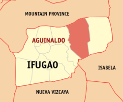
Aguinaldo, Ifugao
| Aguinaldo | |
|---|---|
| Municipality | |
 Map of Ifugao showing the location of Aguinaldo |
|
| Location within the Philippines | |
| Coordinates: 16°47′N 121°19′E / 16.78°N 121.32°ECoordinates: 16°47′N 121°19′E / 16.78°N 121.32°E | |
| Country | Philippines |
| Region | Cordillera Administrative Region (CAR) |
| Province | Ifugao |
| District | Lone District |
| Barangays | 16 |
| Government | |
| • Mayor | Clemente S. Talosig |
| Area | |
| • Total | 538.05 km2 (207.74 sq mi) |
| Population (2015 census) | |
| • Total | 19,408 |
| • Density | 36/km2 (93/sq mi) |
| Time zone | PST (UTC+8) |
| ZIP code | 3606 |
| IDD : area code | +63 (0)74 |
| Income class | 2nd class |
| Website | www |
Aguinaldo is a second class municipality in the province of Ifugao, Philippines. According to the 2015 census, it has a population of 19,408 people.
The economy is mostly agricultural with palay as the main crop.
Aguinaldo is politically subdivided into 16 barangays.
In the 2015 census, the population of Aguinaldo, Ifugao, was 19,408 people, with a density of 36 inhabitants per square kilometre or 93 inhabitants per square mile.
...
Wikipedia

