Agaléga Islands
| Geography | |
|---|---|
| Location | Indian Ocean |
| Coordinates | 10°25′S 56°35′E / 10.417°S 56.583°E |
| Total islands | 2 |
| Area | 24 km2 (9.3 sq mi) |
| Administration | |
| dependency | Agaléga |
| Largest settlement | Vingt Cinq |
| Demographics | |
| Population | 289 (2011) |
| Pop. density | 12 /km2 (31 /sq mi) |
| Ethnic groups | Creole |
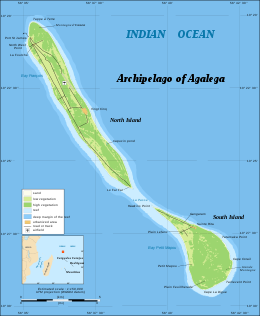
Agaléga (French: îles Agaléga) are two Outer islands of Mauritius located in the Indian Ocean, about 1,000 kilometres (620 mi) north of Mauritius island. The population of the islands as at July 2011 was estimated at 300. The islands have a total area of 2,600 hectares. The North island is 12.5 km long and 1.5 km wide, while the South island is 7 km long and 4.5 km wide. The North Island is home to the islands' airstrip and the capital Vingt Cinq. The islands are known for their coconuts, the production of which is their main industry, and for the Agalega day gecko.
There are three different explanations for the name Agaléga. One hypothesis is that the Portuguese explorer, Dom Pedro Mascarenhas, named Agaléga and the island of Sainte Marie (off the east coast of Madagascar) in honor of his two sailboats, the "Galega" and the "Santa Maria" in 1512, when he discovered Mauritius and Réunion Island.
Another, more probable explanation relates to the Galician explorer João da Nova, who discovered the islands in 1501 while working for the Portuguese. João was popularly known by his sailors as João Galego, according to Jean-Baptiste Benoît Eyriès' Les Nouvelles Annales de Voyage (Volume 38, page 88). Galego is the Galician/Portuguese word for someone from Galicia, North West Spain, and "Agalega", is derived from the feminine version of this ("A" is the feminine article in Galician/Portuguese, and "Island" is feminine, so "A Galega" means "The Galician (Island)").
A further idea comes from a story in Sir Robert Scott's book Limuria: The Lesser Dependencies of Mauritius, where he describes the 1509 discovery of the Islands by the Portuguese mariner Diogo Lopes de Sequeira. According to this version, Diogo named the Islands Baixas da Gale, with the "da Gale" referring to putative gale-force winds hypothetically modelling the coasts of both islands. Scott suggests that maps of the region represented the islands initially as Gale, metamorphosing into Galera, Galega and finally Agalega.
...
Wikipedia

