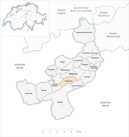
Aetigkofen
| Aetigkofen | ||
|---|---|---|
| Former municipality of Switzerland | ||
|
||
| Coordinates: 47°8′N 7°28′E / 47.133°N 7.467°ECoordinates: 47°8′N 7°28′E / 47.133°N 7.467°E | ||
| Country | Switzerland | |
| Canton | Solothurn | |
| District | Bucheggberg | |
| Area | ||
| • Total | 2.05 km2 (0.79 sq mi) | |
| Elevation | 610 m (2,000 ft) | |
| Population (Dec 2011) | ||
| • Total | 177 | |
| • Density | 86/km2 (220/sq mi) | |
| Postal code | 4583 | |
| SFOS number | 2441 | |
| Surrounded by | Lüterswil-Gächliwil, Mühledorf, Oberramsern, Unterramsern | |
| Website |
www SFSO statistics |
|
Aetigkofen is a former municipality in the district of Bucheggberg in the canton of Solothurn in Switzerland. On 1 January 2014 the former municipalities of Aetigkofen, Tscheppach, Brügglen, Aetingen, Bibern (SO), Gossliwil, Hessigkofen, Mühledorf (SO), Küttigkofen, Kyburg-Buchegg merged into the new municipality of Buchegg.
Aetigkofen is first mentioned in 1034 as Etikhouen.
Before the merger, Aetigkofen had a total area of 2.0 km2 (0.77 sq mi). Of this area, 1.17 km2 (0.45 sq mi) or 57.1% is used for agricultural purposes, while 0.72 km2 (0.28 sq mi) or 35.1% is forested. Of the rest of the land, 0.14 km2 (35 acres) or 6.8% is settled (buildings or roads).
Of the built up area, housing and buildings made up 2.9% and transportation infrastructure made up 3.4%. Out of the forested land, all of the forested land area is covered with heavy forests. Of the agricultural land, 44.4% is used for growing crops and 10.7% is pastures, while 2.0% is used for orchards or vine crops.
The municipality is located in the Bucheggberg district, in the upper Mühle valley on the eastern foot of the Schöniberg mountain. It consists of the haufendorf village (an irregular, unplanned and quite closely packed village, built around a central square) of Aetigkofen and the Mettlen and Chutzenhof farm houses.
The blazon of the municipal coat of arms is Or a Fir tree Vert trunked Gules issuant from a Mount of 3 Coupeaux of the second between two cinquefoils of the third voided.
Aetigkofen had a population (as of 2011) of 177.
...
Wikipedia


