Achada Grande Tras
| Achada Grande Tras | |
|---|---|
| Neighborhood | |

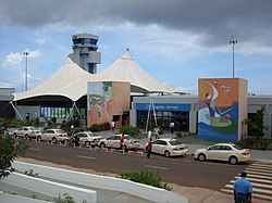
Nelson Mandela International Airport, the airport of the island of Santiago
|
|
| Country | Cape Verde |
| Island | Santiago Island |
| City | Praia |
| Postal code | 7600 |
| Website | www.cmpraia.cv |
Achada Grande Tras (meaning the rear portion of Achada Grande, former spelling: Achada Grande Trás) is a volcanic plateau and a subdivision in the east of Praia in the island of Santiago, Cape Verde and forming the easternmost neighborhood. It is the largest neighborhood in Praia being about 25 square kilometres (9.7 sq mi), 6 km long, and 4 km wide. The highest point is about 120 meters at the extinct volcano, the elevation at the center is about 55 meters, the lowest point is the Atlantic and the Praia Harbor. Other elevations are 67 meters at Monte Faxo, 110 meters at the extinct volcano, 80 to 100 meters at the airport, about 70 meters at Adega and 105 meters at the northwesternmost portion near the Circular Road (EN1-ST06).
Bordering neighbourhoods include Achada Grande Frente and Lem Ferreira and Castelão-Cova Mendes to the west, to the north is São Tomé subdivision. The Atlantic dominates the east and the west.
The center of the neighborhood overlooks the Atlantic Ocean on either sides and has a few ravines. Lesser sports facilities dominates the area.
Portugal never took part in the Anglo-French War which happened between 1778 and 1783 and was a neutral country. The Battle of Porto Praya which involved Great Britain and France took place at the harbor on April 16, 1781, it occurred south of Achada Grande, about 300 to 400 feet (about 100 meters) south, ten British convoys were next to the island, seven were in the vicinity of the two headlands of Ponta de Visconde.
Agriculture dominated the area up to the 2010s when the urban sprawl of Praia spreaded to the area in the 1970s, it was not fully urbanized until the early 2010s in the southern portion, agricultural lands and some forest groves dominates the remainder in the northwest. Urban developments continued up to the present day in the center and now under development especially at the northern estates next to an extinct volcano and a new subdivision, Ponta das Bicudas in the south which started construction in 2014 and is still continuing, except for the east part, most of the promontory has been terraformed and will probably feature hotels and villas.
Once located at Gamboa, the port along with its customs house and ferry services transferred 1 km to the east at the area of Ponta de Visconde in the south. The port underwent expansion in 2009 and finished in 2013 with additional spaces for cargo boats and ferry services in the west. It also added the truck-cargo lots in the east and what was the custom house became a large custom station in the east and connects with the road to Rua de Aeroporto and Avenida de Aristides Pereira. Since the expansion, Ponta do Ponto is the southernmost point of the area which replaced Ponta das Bicudas and is more south than Ilhéu de Santa Maria, the port size is even larger than the nearby islet. Ponta do Porto was once the third southermnost point.
...
Wikipedia
