Abo (historic place)
|
Abo
|
|

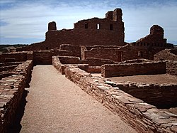
Mission ruins at Abó
|
|
| Nearest city | Abo, New Mexico |
|---|---|
| Coordinates | 34°26′56″N 106°22′17″W / 34.44889°N 106.37139°WCoordinates: 34°26′56″N 106°22′17″W / 34.44889°N 106.37139°W |
| Area | 30 acres (12 ha) |
| Built | 1629 |
| Part of | Salinas Pueblo Missions National Monument (#66000494) |
| NRHP Reference # | 66000497 |
| Significant dates | |
| Added to NRHP | October 15, 1966 |
| Designated NHL | June 13, 1962 |
Abó is a pueblo ruin in New Mexico that is preserved as part of the Salinas Pueblo Missions National Monument. The ruins are located about 9 miles (14 km) west of Mountainair, at about 6100 feet (1859 m) above sea level. They are said to date back to the 14th century. It was a major trading station during its time. There is a visitor contact station, a 0.25 mile (0.4 km) trail through the mission ruins, and a 0.5 mile (0.8 km) trail around the unexcavated pueblo ruins. The site was declared a National Historic Landmark in 1962.
Abo is also the geological type locality for the Abo Formation, which is made up of sandstone red beds and is exposed to the northwest of the Abo ruins.
Abó appears to first enter the documentary historic record in 1583, when a visit to a site believed to be Abó was recorded by the Spanish explorer Antonio de Espejo. Spanish missionary work began there in 1622, and construction of the first church began in 1629. The community, composed of Tampiro-speaking Pueblo Indians, was recorded to have a population of more than 1,600 in 1641. It was abandoned around 1672, apparently due to drought and attacks by Apaches. The Spanish recorded that its residents moved to the Rio Grande valley, where they later sided with the Spanish in the 1680 Pueblo Rebellion.
The site was acquired by the state in 1938, which preserved it as a state historic site. In 2008 it was taken over by the National Park Service as part of the newly enlarged and renamed Gran Quivira National Monument, now the Salinas Pueblos National Monument.
...
Wikipedia


