Abemama

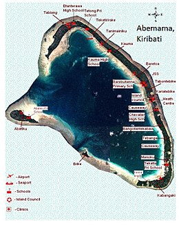
Map of Abemama
|
|
 |
|
| Geography | |
|---|---|
| Location | Pacific Ocean |
| Coordinates | 0°24′N 173°50′E / 0.400°N 173.833°E |
| Archipelago | Gilbert Islands |
| Area | 27.37 km2 (10.57 sq mi) |
| Highest elevation | 3 m (10 ft) |
| Administration | |
| Demographics | |
| Population | 3,213 (2010 Census) |
| Pop. density | 117 /km2 (303 /sq mi) |
| Ethnic groups | I-Kiribati 98.8% |
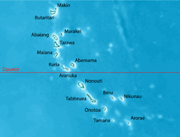
Abemama (Apamama), or for a short time after appearing on European maps, Roger Simpson Island, is an atoll, one of the Gilberts group in Kiribati, and is located 152 kilometres (94 miles) southeast of Tarawa and just north of the Equator. Abemama has an area of 27.37 square kilometres (10.57 square miles) and a population of 3,213 as of 2010[update]. The islets surround a deep lagoon. The eastern part of the atoll of Abemama is linked together by causeways making automobile traffic possible between the different islets. The outlying islands of Abatiku and Biike are situated on the southwestern side of the atoll.
The village of Kariatebike serves as the government center for the atoll which includes an administration building, the police station and a hospital.
Abemama was formerly known as Roger Simpson Island, Dundas Island, Hopper Island, or Simpson Island.
Abemama has a land area of 27.39 square kilometres (11 square miles) with a width varying from 50 metres (160 feet) to 2 kilometres (1.2 miles). The island has 3 main islets; the largest and main islet has 11 villages and is home to most of the population. Abatiku, an islet located at the north-western reef, and Biike just south of it, have much smaller populations.
The island is blessed with a massive lagoon area and an abundance of lagoon fish, shellfish, and worms. There are also some seaweed farms. Causeways were constructed to link all villages on the main islet making transportation easy. The island resembles an incomplete “G” letter, with two reef passages; one is located in between Abatiku and Tabiang village at the north-western end. The other is between Biike and Kenna, the latter being the southernmost end of the main islet. The island is surrounded with an exposed reef at the windward side and submerged reef at the leeward side where Biike and Abatiku are situated. Most of the important food crops in Kiribati such as coconut, giant taro, pandanus and breadfruit grow well in Abemama.
Happened on by Captain Charles Bishop in 1799, he referred to Abemama on the map he created as Roger Simpson Island, after one of his friends.
In the mid to late 19th Century, Abemama was ruled by a single paramount chief. This contrasts with the Northern Gilbert Islands where groups of families or kainga would have their own separate leaders, and the Southern Gilberts (from Nonouti southwards) where the old men or unimwane collectively would meet in the maneaba to govern. Some European sources describe the chiefly family of Abemama as "the Gilbert Islands ruling family" but local sources recognise that the unimwane wield much of the power even on Abemama, and governing the whole of the Gilbert Islands as a single unit is a logistical challenge even in modern times.
...
Wikipedia
