Abbeville, Alabama
| Abbeville | |
|---|---|
| City | |

Historic Downtown Abbeville, Alabama
|
|
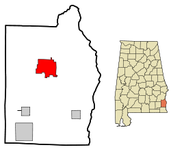
 Location in Henry County and the state of Alabama |
|
| Location in the United States | |
| Coordinates: 31°33′59″N 85°15′5″W / 31.56639°N 85.25139°W | |
| Country | United States |
| State | Alabama |
| County | Henry |
| Government | |
| • Mayor | James Giganti Jr. |
| Area | |
| • Total | 15.6 sq mi (40.4 km2) |
| • Land | 15.5 sq mi (40.3 km2) |
| • Water | 0.1 sq mi (0.1 km2) 0.32% |
| Elevation | 449 ft (137 m) |
| Population (2010) | |
| • Total | 2,688 |
| • Density | 192/sq mi (74.1/km2) |
| Time zone | CST (UTC-6) |
| • Summer (DST) | CDT (UTC-5) |
| ZIP code | 36310 |
| Area code(s) | 334 |
| FIPS code | 01-00124 |
|
|
Abbeville is a city in Henry County, Alabama, United States. It is part of the Dothan, Alabama Metropolitan Statistical Area. At the 2010 census, the population was 2,688. The city is the county seat of Henry County. It is the first city alphabetically, both by city and state, in the Rand McNally Road Atlas. It is home to two high schools: Abbeville High School and Abbeville Christian Academy. It holds chapters of the Red Cross and Habitat for Humanity.
Abbeville is located at 31°33′59″N 85°15′5″W / 31.56639°N 85.25139°WCoordinates: 31°33′59″N 85°15′5″W / 31.56639°N 85.25139°W (31.566367, -85.251300). The city is located in southeastern Alabama along U.S. Route 431, Alabama State Route 10, and Alabama State Route 27 approximately 25 mi (40 km) northeast of Dothan and 23 mi (37 km) south-southwest of Eufaula.
...
Wikipedia

