A78 road (Great Britain)
| A78 | |
|---|---|

Click map to enlarge
|
|

A78 Inverkip bypass
|
|
| Major junctions | |
| South end: |
Greenock 55°56′54″N 4°45′26″W / 55.9484°N 4.7571°W |
| North end: |
Monkton 55°31′29″N 4°35′26″W / 55.5246°N 4.5906°W |
| Location | |
|
Primary destinations: |
Greenock, Irvine, Prestwick Airport |
| Road network | |
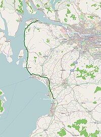
The A78 is an A road in Scotland. It connects Greenock and Prestwick on a route which follows the northern section of the Ayrshire coast.
The A78 begins in Greenock, Renfrewshire as a continuation of the A8 road at the Bull Ring roundabout, and runs in a southerly direction through the Spango Valley, Inverkip, Wemyss Bay, Largs, Seamill and then bypasses the major towns of Ardrossan, Irvine and Troon amongst others before terminating near Prestwick, Ayrshire, where it forms a junction with the A77.
Much of the road is single carriageway - both for a short distance through Greenock and a 21-mile stretch between Inverkip and Ardrossan.
The rest is dual carriageway - between the Eglinton and Warrix interchanges there are in fact 3 lanes in each direction, and the road is constructed to motorway standard (with full grade separation at junctions) save for a lack of hard shoulders. The road very rarely appears busy on this stretch - the adjacent New Town development area of Irvine, North Ayrshire (which includes Kilwinning, Dreghorn and Girdle Toll) had a population of just over 50,000 in the 2001 census; the town planners designed the infrastructure for a population more in the region of 120,000.
...
Wikipedia

