A75 road
| A75 | |
|---|---|
 |
|

Barholm Wood, between Castle Douglas and Newton Stewart
|
|
| Route information | |
| Part of |
|
| Length: | 95.4 mi (153.5 km) |
| Existed: | 1923 – present |
| Major junctions | |
| East end: | Gretna |
|
J22 → A74(M) motorway |
|
| West end: | Stranraer |
| Location | |
|
Primary destinations: |
Carlisle, Gretna, Dumfries, Stranraer |
| Road network | |
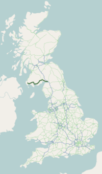
The A75 is a Primary Trunk Road in Scotland, linking Stranraer and its ferry ports at Cairnryan with the A74(M) at Gretna, close to the Border with England and the M6 Motorway. Also home to Ana
Heading west along the south coast of Scotland from its junction with the A74(M) motorway at Gretna it continues past Eastriggs, Annan, Dumfries, Castle Douglas, Gatehouse of Fleet, Newton Stewart, Kirkcowan and Glenluce before ending at Stranraer.
The majority of the road is of single-carriageway standard, although a few short dual carriageway sections exist, including a one-mile section past Gretna, a section past Collin (just east of Dumfries,) a two-mile section just west of Dumfries and a 1-mile section at Barlae (Between Glenluce and Newton Stewart.)
There are also numerous 3 lane, Overtaking sections which allow overtaking in one direction or on some occasion both directions. The road is currently being re-routed at Carrutherstown (near Dumfries) and a bypass has been constructed to avoid the village of Dunragit and the frequently struck Challoch Railway Bridge, which has earned the title of "most hit bridge in the UK ".
...
Wikipedia

