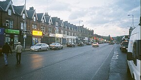
A58 road
| A58 | |
|---|---|
 |
|

|
|
| Route information | |
| Length: | 75 mi (121 km) |
| Major junctions | |
| West end: | Prescot |
| East end: | Wetherby |
| Location | |
|
Primary destinations: |
St Helens Bolton Bury Rochdale Halifax Leeds |
| Road network | |
The A58 is a major road in northern England that runs between Prescot, Merseyside and Wetherby, West Yorkshire.
It runs north east from Prescot on the outskirts of Liverpool via St Helens, Ashton-in-Makerfield, Hindley, Westhoughton, Bolton, Bury, Heywood, Rochdale and Littleborough, then over the Pennines into West Yorkshire.
The road then goes through Ripponden and Sowerby Bridge to Halifax and onwards to Leeds via the villages of Hipperholme, Birkenshaw and Drighlington. It runs through Leeds as the A58(M) motorway (part of the Leeds Inner Ring Road), then north-east through Scarcroft, Bardsey and Collingham to its terminus at Wetherby.
...
Wikipedia

