A18 road (Great Britain)
| A18 | |
|---|---|
 |
|
| Major junctions | |
| From: |
Doncaster 53°30′53″N 1°08′19″W / 53.5147°N 1.1386°W |
| To: |
Ludborough 53°26′02″N 0°02′28″W / 53.4338°N 0.0412°W |
| Location | |
|
Primary destinations: |
Scunthorpe |
| Road network | |
| A18(M) | |
|---|---|
 |
|
| Route information | |
| Length: | 1.0 mi (1.6 km) |
| Existed: | 1972 – present |
| Road network | |
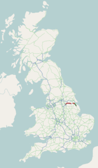
The A18 is a road in England that links Doncaster in South Yorkshire with Ludborough in Lincolnshire, via Scunthorpe.
It begins as a dual-carriageway and trunk road at the Balby Flyover junction with the A630 in Balby in Doncaster, under which runs the East Coast Main Line. It meets the A638 (former Great North Road) at the Sidings Roundabout then becomes Carr House Road, overlapping the A638. At the Racecourse Roundabout in Belle Vue, the A638 leaves to the right (former Great North Road), and the road becomes Leger Way, passing the Doncaster College for the Deaf on the left, and Doncaster Racecourse on the right. Near Intake, it becomes single carriageway, which it continues as for most of its length until it reaches Scunthorpe and also in Grimsby. On the right is Danum Academy (Danum is the Roman name for Doncaster) and Sandall Wood School, a special needs school. There is a roundabout with Armthorpe Road, with Wheatley Hills to the left and Wheatley Golf Club to the right. At the Sandall Park Roundabout the road meets its old route and becomes Thorne Road. At the Shaw Lane Roundabout it meets the A630, with exits for Shaw Lane Industrial Estate, and the road overlaps the A630 under a railway line. At the next roundabout, on the edge of Doncaster, the A630 leaves to the right, as a trunk road to the M18, with Edenthorpe Sainsbury's an exit to the south. The road, now without trunk (primary) status, passes Hungerhill School on the left near The Ridgewood pub and passes through Edenthorpe.
...
Wikipedia

