96th Street (Manhattan)

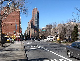
Crossing First Avenue, looking west
|
|
| Owner | City of New York |
|---|---|
| Maintained by | NYCDOT |
| Length | 1.3 mi (2.1 km) |
| Width | 100 feet (30.48 m) |
| Location | Manhattan |
| Postal code | 10025 (west), 10128 (east) |
| Coordinates | 40°47′39″N 73°58′13″W / 40.794051°N 73.970368°WCoordinates: 40°47′39″N 73°58′13″W / 40.794051°N 73.970368°W |
| West end |
|
| East end |
|
| North | 97th Street |
| South | 95th Street |
| Construction | |
| Commissioned | 1811 |
96th Street is a major two-way street in the Upper East Side and Upper West Side sections of the New York City borough of Manhattan, running from the East River at the FDR Drive to the Henry Hudson Parkway at the Hudson River. It is one of the 15 hundred-foot-wide (30 m) crosstown streets mapped out in the Commissioner's Plan of 1811 that established the numbered street grid in Manhattan.
East and West 96th Street are separated by Central Park, whose West 96th Street pedestrian gate is called "Gate of all Saints" and whose East 96th Street gate is called "Woodmans Gate". A sunken roadway through the park, often called the 97th Street Transverse road or Transverse Road #4, connects the East and West Sides via 96th and 97th Streets.
96th Street is the northern boundary of the New York City steam system, the largest such system in the world, which pumps 30 billion pounds of steam into 100,000 buildings south of the street.
From the FDR Drive to First Avenue, 96th Street is the northern border of Zone A, a flood evacuation zone. When Hurricane Sandy hit New York City in 2012, residents on neighboring blocks found out they, too, were in a flood zone, and the city revised its zone borders outward. Residents of the public housing projects as well as high rise apartments in the zone were left without power, although it was restored to most of the area after a day or two.
...
Wikipedia
