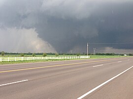
2013 Moore tornado
| EF5 tornado | |
|---|---|

The tornado as it was approaching the city of Moore
|
|
| Formed | 2:56 p.m. CDT (UTC−05:00), May 20, 2013 |
| Dissipated | 3:33 p.m. CDT (UTC−05:00), May 20, 2013 |
| Max rating1 | EF5 tornado |
| Highest winds |
|
| Damage | $2 billion (estimate) |
| Casualties | 24 fatalities (+1 indirect), 212 injuries |
| Areas affected | McClain and Cleveland counties in Oklahoma; particularly the city of Moore |
| 1Most severe tornado damage; see Enhanced Fujita scale | |
National Weather Service tornado damage survey map: Bing / Google
On the afternoon of May 20, 2013, an intense and destructive EF5 tornado struck Moore, Oklahoma, and adjacent areas, with peak winds estimated at 210 mph (340 km/h), killing 24 people (plus one indirect fatality) and injuring 377 others. The tornado was part of a larger weather system that had produced several other tornadoes across the Great Plains over the previous two days, including five that struck portions of Central Oklahoma the day prior on May 19.
The tornado touched down just northwest of Newcastle at 2:56 p.m. CDT (19:46 UTC), and stayed on the ground for 37 minutes over a 17-mile (27 km) path, crossing through a heavily populated section of Moore. The tornado was 1.3 miles (2.1 km) wide at its peak. It followed a roughly similar track to the deadlier 1999 Bridge Creek–Moore tornado, which was similar in size and severity; however, very few homes and neither of the stricken schools in the area had purpose-built storm shelters in the intervening years since the earlier tornado struck Moore.
On May 20, 2013, a prominent central upper trough moved eastward toward the Central United States, with a lead upper low pivoting over the Dakotas and Upper Midwest region. A Southern stream shortwave trough and a moderately strong polar jet moved east-northeastward over the southern Rockies to the southern Great Plains and Ozarks area, with severe thunderstorms forming during the peak hours of heating. With the influence of moderately strong cyclonic flow aloft, the air mass was expected to become unstable across much of the southern Great Plains, Ozarks and middle Mississippi Valley by the afternoon.
...
Wikipedia
