2012–13 North American winter

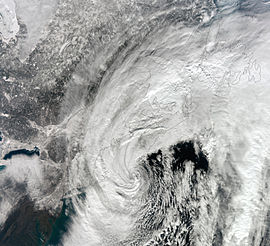
NASA satellite image of the strong nor'easter over New England on February 9, 2013.
|
|
| Astronomical winter | December 21 – March 20 |
|---|---|
| Meteorological winter | December 1 – February 28 |
The 2012–13 North American winter refers to winter as it occurred across the continent from late 2012 through early 2013. While there is no well-agreed-upon date used to indicate the start of winter in the Northern Hemisphere, there are two definitions of winter which may be used. Based on the astronomical definition, winter begins at the winter solstice, which in 2012 occurred late on December 21, and ends at the March equinox, which in 2013 occurred on March 20. Based on the meteorological definition, the first day of winter is December 1 and the last day February 28. Both definitions involve a period of approximately three months, with some variability.
On October 18, 2012, the National Oceanic and Atmospheric Administration's Climate Prediction Center issued its U.S. Winter Outlook. In the outlook, little rainfall was anticipated in the Northwestern United States and the Upper Midwest, while above-average precipitation was anticipated in the Southeastern United States. Equal levels of precipitation and temperatures were expected in the Alaskan panhandle. Below-average temperatures were favored in Florida, while above-average temperatures were favored in much of the Western United States, and northern Alaska. The remainder of the country fell into the outlook's "equal chance" category, with an equal chance of above-average, below-average, and near-average temperatures and/or precipitation.
On October 29, 2012, Hurricane Sandy made landfall in southern New Jersey as an 80 mph (130 km/h) Category 1 post-tropical cyclone. While initially bringing historic storm surge, damaging winds and heavy rainfall, many were shocked at how this storm (dubbed a 'super'storm by many news outlets and sources) was able to produce snow in its massive circulation. The snowstorm section of the hurricane dumped as much as 28 inches (71 cm) of snow in the higher terrains of West Virginia and northern Virginia.
The reason why Sandy was able to produce such a snowstorm was due to a blast of arctic air – associated with the polar vortex – that had plunged into the Northeast, which led to Sandy actually maintaining its intensity while subsequently deepening before landfall. About a week later, the same areas affected by Sandy were pounded by an early season nor'easter, further hindering recovery efforts in those areas.
...
Wikipedia
