2011 Pakistan floods

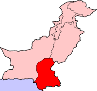
Location of Sindh,
|
|
| Date | August 2011–September 2011 |
|---|---|
| Location | Sindh, southern Balochistan, eastern Punjab and Azad Kashmir |
| Deaths | At least 434 dead, 8.9 million affected |
| Property damage | 8.9 million affected, 2.7 million children affected, 6.79 million acres land damaged, 1.52 million homes damaged |
The flood was originated mostly because of rainfall and observed the highest ever recorded monsoon rain in Sindh started from Aug 11, 2011 to Sept 14, 2011. So the inundated area increased respectively with rainfall and ceased on Sept 15, 2011 effectively with the stop of rainfall. After Sept 15, 2011 the inundated area was reduced with the rate of 167 km2/day. The floods caused considerable damage; an estimated 434 civilians were killed, with 5.3 million people and 1,524,773 homes affected. Sindh is a fertile region and often called the "breadbasket" of the country; the damage and toll of the floods on the local agrarian economy was extensive. At least 1.7 million acres of arable land was inundated as a result of the flooding. The flooding followed the previous year's historic 2010 Pakistan floods, which devastated the entire country. Unprecedented torrential monsoon rains caused severe flooding in 16 districts of Sindh province.
In the month of July Pakistan received below normal monsoon rains; however in August and September the country received above normal monsoon rains. A strong weather pattern entered the areas of Sindh from the Indian states of Rajasthan and Gujarat in August and gained strength with the passage of time and caused heavy downpours. The four weeks of continuous rain have created an unprecedented flood situation in Sindh.
The District Badin in Sindh province received record breaking rainfall of 615.3 millimeters (24.22 in) during the monsoon spell breaking earlier recorded 121 millimeters (4.8 in) in Badin in 1936. The area of Mithi also received record rainfall of 1,290 millimeters (51 in) during the spell, where maximum rainfall was recorded 114 millimeters (4.5 in) in Mithi in 2004. The heavy cloudburst during last 48–72 hours displaced many people besides destroying crops in the area. The Met Office had informed all district coordination officers, Provincial Disaster Management Authority, chief secretaries and chief ministers about the heavy monsoon rain-spell two days earlier to take precautionary measures.
It was found that severe flood occurred in Badin and inundated it by 3820.39 km2, Mirpurkhas by 1836.26 km2, Jacobabad by 1352.32 km2, Shahdadkot by 1597.50 km2, Dadu by 1887.57 km2 and Sanghar by 2494.18 km2, in cumulative. Furthermore, the above-mentioned districts contributed 61% of the total inundated area among 23 districts in Sindh.
...
Wikipedia
