2011 Halloween nor'easter
| Category 1 "Notable" (RSI: 1.97) | |

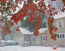
Snow falling on autumn leaves in Walden, NY
|
|
| Type |
Extratropical cyclone Nor'easter Blizzard Winter storm |
|---|---|
| Formed | October 28, 2011 |
| Dissipated | November 1, 2011 (moved out to sea) |
| Lowest pressure | 971 mb (28.7 inHg) |
| Maximum snowfall or ice accretion | 32 inches (81 cm), Peru, Massachusetts |
| Areas affected | Northeastern United States, Atlantic Canada |
The 2011 Halloween nor'easter, sometimes referred to as "Snowtober" and "Storm Alfred", was a large low pressure area that produced unusually early snowfall across the northeastern United States and the Canadian Maritimes. It formed early on October 29 along a cold front to the southeast of the Carolinas. As it moved up the East Coast, its associated snowfall broke records in at least 20 cities for total accumulations, resulting in a rare "white Halloween" two days later.
The storm arrived just two months after Hurricane Irene caused extensive power outages and property damage in the Northeast; with the 2011 New England tornado outbreak also causing damage in Western Massachusetts.
The nor'easter dumped snow on trees that were often still in leaf, adding extra weight, with the ground in some areas still soft from a preceding warm, rainy period that increased the possibility trees could be uprooted. Trees and branches that collapsed caused considerable damage, particularly to power lines, with estimates of storm costs ranging between $1 billion and $3 billion. In all, 3.2 million U.S. residences and businesses in 12 states experienced power outages, with the storm also impacting three Canadian provinces.
In some areas of Connecticut, outages lasted as long as 11 days. Many communities chose to postpone celebrations of Halloween from two days to a week later as a result, or cancel them entirely. Delays in restoring power led to the resignation of the chief operating officer of Connecticut Light & Power amid widespread criticism of the company's mishandling of both the nor'easter and Irene.
Early on October 28, 2011, a ridge over Canada advected an unseasonably cold air mass across the Mid-Atlantic states and New England; at the same time, a surface low-pressure area began developing along the coast of Louisiana. A cold front moved eastward from the Ohio Valley and exited the East Coast of the United States, developing another low pressure area off the coast of the Carolinas on October 29. The remnants of Hurricane Rina had also been absorbed into the developing system. At the same time, an area of precipitation extended from South Carolina through Pennsylvania, mostly falling as rain with some snow observed at higher elevations. By late that morning, the system was producing precipitation over much of the Mid-Atlantic and New England.
...
Wikipedia
