1980 Pacific typhoon season
| 1980 Pacific typhoon season |

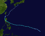
Season summary map
|
| Seasonal boundaries |
| First system formed |
February 12, 1980 (officially March 19)
|
| Last system dissipated |
December 21, 1980 |
| Strongest storm |
|
| Name |
Wynne |
| • Maximum winds |
220 km/h (140 mph)
(10-minute sustained) |
| • Lowest pressure |
890 hPa (mbar) |
| Seasonal statistics |
| Total depressions |
44 (2 unofficial)
|
| Total storms |
24 |
| Typhoons |
15 |
| Super typhoons |
2 (unofficial)
|
| Total fatalities |
> 131 |
| Total damage |
Unknown |
| Related articles |
|
|
Pacific typhoon seasons
1978, 1979, 1980, 1981, 1982
|
| Tropical depression (PAGASA) |
|
|
| Duration |
February 12 – February 14 |
| Peak intensity |
55 km/h (35 mph) (10-min) |
| Tropical depression (JMA) |
| Tropical depression (SSHWS) |
|
|
| Duration |
March 19 – March 29 |
| Peak intensity |
55 km/h (35 mph) (1-min) 1002 hPa (mbar) |
| Severe tropical storm (JMA) |
| Tropical storm (SSHWS) |
|
|
| Duration |
April 5 (entered basin) – April 7 (exited basin) |
| Peak intensity |
110 km/h (70 mph) (10-min) 985 hPa (mbar) |
| Tropical depression (PAGASA) |
|
|
| Duration |
April 28 – May 1 |
| Peak intensity |
55 km/h (35 mph) (10-min) |
| Typhoon (JMA) |
| Category 2 typhoon (SSHWS) |
|
|
| Duration |
May 7 – May 22 |
| Peak intensity |
155 km/h (100 mph) (10-min) 960 hPa (mbar) |
| Typhoon (JMA) |
| Category 3 typhoon (SSHWS) |
|
|
| Duration |
May 13 – May 22 |
| Peak intensity |
195 km/h (120 mph) (10-min) 930 hPa (mbar) |
| Severe tropical storm (JMA) |
| Tropical storm (SSHWS) |
|
|
| Duration |
May 19 – May 26 |
| Peak intensity |
100 km/h (65 mph) (10-min) 992 hPa (mbar) |
| Severe tropical storm (JMA) |
| Tropical storm (SSHWS) |
|
|
| Duration |
May 19 – May 25 |
| Peak intensity |
100 km/h (65 mph) (10-min) 980 hPa (mbar) |
| Severe tropical storm (JMA) |
| Tropical storm (SSHWS) |
|
|
| Duration |
June 22 – June 29 |
| Peak intensity |
95 km/h (60 mph) (10-min) 990 hPa (mbar) |
The 1980 Pacific typhoon season has no official bounds; it ran year-round in 1980, but most tropical cyclones tend to form in the northwestern Pacific Ocean between June and December. These dates conventionally delimit the period of each year when most tropical cyclones form in the northwestern Pacific Ocean. Tropical storms which formed in the entire west Pacific basin were assigned a name by the Joint Typhoon Warning Center. Tropical depressions that enter or form in the Philippine area of responsibility are assigned a name by the Philippine Atmospheric, Geophysical and Astronomical Services Administration or PAGASA. This can often result in the same storm having two names.
A total of 28 tropical depressions formed this year in the Western Pacific, of which 24 became tropical storms. Beginning in March, tropical cyclones formed in each subsequent month through December. Of the 28, 15 storms reached typhoon intensity, of which 2 reached super typhoon strength. Seven tropical cyclones moved through the Philippines this season.
A total of 28 tropical depressions formed this year in the Western Pacific, of which 24 became tropical storms. Of the 28, 15 storms reached typhoon intensity, of which 2 reached super typhoon strength. Seven tropical cyclones moved through the Philippines this season.
On April 4, a tropical depression formed just east of the International Date Line. At the time, the Joint Typhoon Warning Center (JTWC) designated it tropical depression 02W. As it moved generally northwestwards, it strengthened into a tropical storm just before crossing the dateline, but only received a name in the northwest Pacific, being dasignated Carmen. After peaking with maximum sustained winds of 70 mph (110 km/h) on April 6,Carmen recurved northeast and crossed the International Date Line, entering the central Pacific on April 7. The JTWC subsequently relinquished responsibility to the Central Pacific Hurricane Center. Carmen lost its initial motion and stalled in the area, ultimately weakening in to a tropical depression on April 8. The depression dissipated the following day and the remnant low returned to western Pacific.
...
Wikipedia


