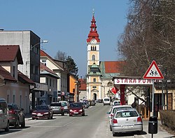
Šentvid, Ljubljana
| Šentvid | |
|---|---|
 |
|
| Location in Slovenia | |
| Coordinates: 46°5′50″N 14°27′59″E / 46.09722°N 14.46639°ECoordinates: 46°5′50″N 14°27′59″E / 46.09722°N 14.46639°E | |
| Country |
|
| Traditional region | Upper Carniola |
| Statistical region | Central Slovenia |
| Municipality | Ljubljana |
| Elevation | 316 m (1,037 ft) |
Šentvid (pronounced [ʃɛnˈtʋiːt]; formerly also Šent Vid nad Ljubljano,German: Sankt Veit) is a part of Ljubljana, the capital of Slovenia. Until 1974 an independent village in Upper Carniola, it is today the centre of the Šentvid District, one of the districts of the Municipality of Ljubljana.
Šentvid was first mentioned in written sources in 1262 as plebanus Sancti Viti. The Slovene name Šentvid is a compound of Slovene šent 'saint' and Vid 'Vitus', referring to the parish church. In the past, the village was also known as Šent Vid nad Ljubljano (literally, 'Saint Vitus above Ljubljana'). The settlement was known as Sankt Veit in German.
The central street in Šentvid was named Prušnik Street (Slovene: Prušnikova ulica) in 1980 after the Carinthian Slovene Partisan activist Karel Prušnik (1910–1980). Until 1977, it was part of Klagenfurt Street (Celovška cesta), one of the main city arteries. The current Klagenfurt Street bypasses the central part of Šentvid along its western side.
Šentvid was already inhabited in prehistoric times. Archaeological finds from the area include a lance from the Urnfield culture, an arrow from the Hallstatt culture, and a Celtic silver coin. A prehistoric fortress stood on Big Trata Hill (Slovene: Velika Trata) west of the village, and Roman coins have been found in the settlement.
An elementary school was established in Šentvid in 1866, and a four-year lower secondary school was established in 1928. The St. Stanislaus Institute, an upper secondary school, was established in 1901.
...
Wikipedia

