Říp Mountain
| Říp Mountain | |
|---|---|

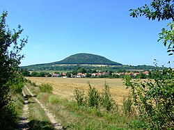
Říp from the south
|
|
| Highest point | |
| Elevation | 459 m (1,506 ft) |
| Prominence | 200 m (660 ft) |
| Coordinates | 50°23′11″N 14°17′18″E / 50.38639°N 14.28833°ECoordinates: 50°23′11″N 14°17′18″E / 50.38639°N 14.28833°E |
| Geography | |
| Location | Czech Republic |
| Parent range | Central Bohemia |
Říp Mountain (Czech: hora Říp, IPA: [ˈɦora ˈr̝iːp]), also known as Říp Hill, is a 459 m solitary hill rising up from the central Bohemian flatland where, according to legend, the first Czechs settled. Říp is located 20 km south-east of Litoměřice, Czech Republic.
Geologically, Říp is the erosional remnant of a Late Oligocene volcano and is composed of basalt nephelites containing olivine granules, amphibole, leucite and — among others — magnetite, so a local magnetic anomaly can even be observed there by the compass. The hill was bare until 1879 when Mořic Lobkowitz had it planted with trees. Today, almost all of the mountain is covered by an oak-and-hornbeam forest with some maple, pine ash, and linden trees. Some rare thermophile plants can be found at the few tree-less places on the top of the hill, such as Gagea bohemica and Iris pumila.
Říp, being visible from great distance, has always been an important orientation point in the Bohemian scenery and has attracted attention since the oldest times. The name of the mountain is of pre-Slavic origin and probably comes from the Germanic stem *rīp- which means "an elevation, a hill".
...
Wikipedia

