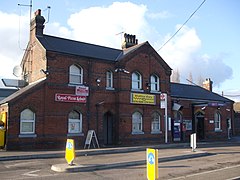
South Ockendon
| South Ockendon | |
|---|---|
 Ockendon Station |
|
| South Ockendon shown within Essex | |
| OS grid reference | TQ592827 |
| Unitary authority | |
| Ceremonial county | |
| Region | |
| Country | England |
| Sovereign state | United Kingdom |
| Post town | SOUTH OCKENDON |
| Postcode district | RM15 |
| Dialling code | 01708 |
| Police | Essex |
| Fire | Essex |
| Ambulance | East of England |
| EU Parliament | East of England |
| UK Parliament | |
South Ockendon is a settlement and Church of England parish in the Thurrock borough and unitary district in Essex in the East of England, United Kingdom. Located on the border with Greater London just outside the M25 motorway. The area to the north is North Ockendon.
South Ockendon is an ancient parish. It was a village before the Norman Conquest, had a priest in 1085. is listed in the Domesday Book as "Wocheduna", conjecturally named after a Saxon chief, Wocca, whose tribe allegedly lived on a hill. The suffix "don" in Old English means a low hill in open country. Until the late 1940s, the village centred on The Village Green, with its Norman Church of St. Nicholas of Myra and adjoining "The Royal Oak" a 14th-century tavern with a 17th-century northern extension. North, South and West Roads all converge on The Green. The railway through Ockendon station was built in 1892 as a through line from Tilbury Dock to the Midlands and further via Upminster and Romford and now is a major commuter route between Southend and Fenchurch Street via Barking.
In 1912, "Mollands Farm" to the south of the original village was acquired for use as a 'rehabilitation' facility for what are now termed 'disadvantaged' or 'educationally challenged' people who were put to useful work on the farm. Over time the farm developed into a major mental hospital (known locally as The Colony) or as South Ockendon Psychiatric Hospital. The hospital closed in 1993 and was demolished in 1998 (This date is disputed as there were already houses on the site as early as 1996) as an indirect result of the devastating "South Ockendon Report" which re-defined the borders of bad management of mental patients and led to a nationwide re-appraisal of mental care in the UK. Redevelopment of the former hospital site followed from early 1997. It had been proposed to convert The Colony into a prison but reason prevailed when it was realised that Thurrock Borough Council had a potential 'nice little earner' by approving the building of a major housing estate comprising 688 high spec. dwellings which would attract a very substantial return in "Council Tax". This estate was built in modules, by various well-respected developers,over a four-year period and is now known as The Brandon Groves Estate. The estate covers about 100acres with extensive lawns, walks and over 3.5 miles of paved access roads. It is furnished by dozens of long established trees but (as of 2015) maintenance is somewhat neglected by Thurrock Borough Council.
...
Wikipedia

