Susumansky District
| Susumansky District Сусуманский район (Russian) |
|
|---|---|
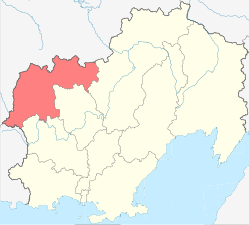
 Location of Susumansky District in Magadan Oblast |
|
| Coordinates: 63°N 147°E / 63°N 147°ECoordinates: 63°N 147°E / 63°N 147°E | |
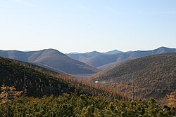
 Burkhalinsky Pass as seen from the Susuman side |
|
|
|
|
| Location | |
| Country | Russia |
| Federal subject | Magadan Oblast |
| Administrative structure (as of July 2012) | |
| Administrative center | town of Susuman |
| Inhabited localities: | |
| Cities/towns | 1 |
| Urban-type settlements | 6 |
| Rural localities | 6 |
| Municipal structure (as of July 2010) | |
| Municipally incorporated as | Susumansky Municipal District |
| Municipal divisions: | |
| Urban settlements | 3 |
| Rural settlements | 1 |
| Statistics | |
| Area | 46,800 km2 (18,100 sq mi) |
| Population (2010 Census) | 9,015 inhabitants |
| • Urban | 97.1% |
| • Rural | 2.9% |
| Density | 0.19/km2 (0.49/sq mi) |
| Time zone | MAGT (UTC+11:00) |
| Established | December 3, 1953 |
| on | |
Susumansky District (Russian: Сусума́нский райо́н) is an administrative and municipal district (raion), one of the eight in Magadan Oblast, Russia. It is located in the northwest of the oblast. The area of the district is 46,800 square kilometers (18,100 sq mi). Its administrative center is the town of Susuman. Population: 9,015 (2010 Census); 14,022 (2002 Census);47,950 (1989 Census). The population of Susuman accounts for 65.0% of the district's total population.
The district was established on December 3, 1953.
Despite being rich in natural resources, the economy of the district suffered in recent years. The severe climate and poorly developed infrastructure are partly to blame, but the difficult transition from Soviet times has led to the collapse of a number of companies with the result that many inhabitants have left the region.
The main industries of Susumansky District are gold and coal mining.
Arkagala, Belichan, Bolshevik, Burkandya, Kadykchan, Kamenisty, Kemendzha, Kerdovy, Kontrandya, Maldyak, Neksikan, Ozyornoye, Udarnik, Ust-Khakchan.
...
Wikipedia

