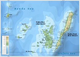
Kei Island
| Native name: KaiKai | |
|---|---|

Kai islands
|
|
 |
|
| Geography | |
| Location | South-east Asia |
| Coordinates | 5°45′S 132°44′E / 5.75°S 132.73°E |
| Total islands | 47 |
| Major islands | Kai Besar, Kai Kecil |
| Area | 1,438 km2 (555 sq mi) |
| Highest elevation | 90 m (300 ft) |
| Highest point | 82 meters altitude |
| Administration | |
| Province | Maluku |
| Largest settlement | Alaku Malaki |
The Kai Islands (also Kei Islands) of Indonesia are a group of islands located in the southeastern part of the Maluku Islands in Maluku Province. The Malakus have also been known as the Spice Islands due to regionally specific plants such as nutmeg, mace, and cloves that originally intrigued the European nations of the 16th century.
Though originally Melanesian, many islanders were exterminated in the 17th century during the spice wars, particularly in the Banda Islands. A second influx of Austronesian immigrants began in the early twentieth century under the Dutch and continued in the Indonesian era.
The islands consist of the Southeast Maluku Regency (Maluku Tenggara) within the Maluku Province. The Regency is sub-divided into six districts (kecamatan). Though geographically within the Kai Islands, the city of Tual is the capital of the Southeast Maluku Regency of Indonesia, but not a member of the Regency.
The Kai islands are a part of the Wallacea, the group of Indonesian islands that are separated by deep water from both the Asian and Australian continental shelves, and were never linked to either continent. As a result, the Kai Islands have few native mammals and are a part of the Banda Sea Islands moist deciduous forests ecoregion. Kai Besar in particular is mountainous and densely forested. Kai is also famous for the beauty of its beaches, notably in Pasir Panjang.
...
Wikipedia
