Cross and Burness, Orkney
| Norse name | Sandey |
|---|---|
| Meaning of name | Old Norse: sand island |
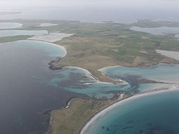
 An aerial view of the southern coast of Sanday, looking west. Tres Ness and Conninghole are in the foreground. |
|
| Location | |
|
Sanday shown within Orkney
|
|
| OS grid reference | HY677411 |
| Coordinates | 59°15′N 2°33′W / 59.25°N 2.55°W |
| Physical geography | |
| Island group | Orkney |
| Area | 5,043 ha (19.5 sq mi) |
| Area rank | 21 |
| Highest elevation | The Wart 65 m (213 ft) |
| Administration | |
| Sovereign state | United Kingdom |
| Country | Scotland |
| Council area | Orkney Islands |
| Demographics | |
| Population | 494 |
| Population rank | 22 |
| Population density | 9.8 people/km2 |
| Largest settlement | Lady |
| References | |

Start Point Lighthouse in 2007
|
|
|
Orkney
|
|
| Location | Start Point Sanday Orkney Scotland United Kingdom |
|---|---|
| Coordinates | 59°16′39″N 2°22′33″W / 59.277431°N 2.375906°W |
| Year first constructed | 1806 (first) |
| Year first lit | 1870 (current) |
| Automated | 1962 |
| Construction | stone tower |
| Tower shape | cylindrical tower with balcony and lantern |
| Markings / pattern | white and black vertical stripes tower, black lantern, ochre trim |
| Height | 25 metres (82 ft) |
| Focal height | 24 metres (79 ft) |
| Light source | solar power |
| Range | 24 nautical miles (44 km; 28 mi) |
| Characteristic | Fl (2) W 20s. |
| Admiralty number | A3718 |
| NGA number | 3276 |
| ARLHS number | SCO-225 |
| Managing agent |
Northern Lighthouse Board |
| Heritage | category B listed building |
|
[]
|
|
Sanday is one of the inhabited islands of Orkney that lies off the north coast of mainland Scotland. With an area of 50.43 square kilometres (19.5 sq mi), it is the third largest of the Orkney Islands. The main centres of population are Lady Village and Kettletoft. Sanday can be reached by Orkney Ferries or by plane from Kirkwall on the Orkney Mainland.
The Picts were the pre-Norse inhabitants of Sanday but very few placenames remain from this period. The Norse named the island Sandey or Sand-øy because of the predominance of sandy beaches and this became "Sanday" during the Scots and English speaking periods. The similarly named Sandoy is in the Faroe Islands.
Many places and natural features derive from Old Norse. According to Dorward (1995), the placename Kettletoft means "Kettil's croft" although "toft" in this context may mean ""abandoned site of house" from the Norse topt. The suffix -bister found in Sellibister and Overbister is from bólstaðr meaning "dwelling" or "farm". Other common suffixes are -wick and -ness from the Norse vik and nes and meaning "bay" and "headland" respectively. According to Frances Groome, Otterswick was originally known as Odinswic.
Sanday lies south of North Ronaldsay and east of Eday and Westray. It is divided naturally into two roughly equal halves by Otterswick, a bay which runs in from the north, and Kettletoft Bay in the south. The narrow isthmus between them formed the boundary between the historic parishes Cross and Burness to the west and Lady to the east. The novelist Eric Linklater described Sanday's shape seen from the air as being like that of a giant fossilised bat.
...
Wikipedia


