Wirt County, West Virginia
| Wirt County, West Virginia | |
|---|---|

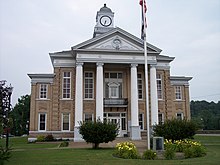
The Wirt County Courthouse in Elizabeth
|
|
 Location in the U.S. state of West Virginia |
|
 West Virginia's location in the U.S. |
|
| Founded | January 19, 1848 |
| Named for | William Wirt |
| Seat | Elizabeth |
| Largest town | Elizabeth |
| Area | |
| • Total | 235 sq mi (609 km2) |
| • Land | 233 sq mi (603 km2) |
| • Water | 2.3 sq mi (6 km2), 1.0% |
| Population (est.) | |
| • (2015) | 5,880 |
| • Density | 25/sq mi (10/km²) |
| Congressional district | 2nd |
| Time zone | Eastern: UTC-5/-4 |
| Website | www |
Wirt County is a county in the U.S. state of West Virginia. As of the 2010 census, the population was 5,717, making it the least populous county in West Virginia. Its county seat is Elizabeth. The county was created in 1848 by the Virginia General Assembly and named for U.S. Attorney General and presidential candidate William Wirt. The county is serviced by one high school, Wirt County High School.
Wirt County is part of the Parkersburg-Vienna, WV Metropolitan Statistical Area, which is part of the Parkersburg-Marietta-Vienna, WV-OH Combined Statistical Area.
Wirt County was created from parts of Jackson and Wood counties on January 19, 1848. The county was named for William Wirt (1772–1834).
The first European pioneer was William Beauchamp (1743-1808), a veteran of the Continental Navy and a Methodist minister. Beauchamp arrived in 1796 with a claim to 1400 acres on the Little Kanawha river. He farmed, built a mill, and laid out the town of Elizabeth, named after his daughter.
Burning Springs was the site of an oil rush in the 1860s. In 1863 the town was burned, along with 100,000 gallons of oil, by Confederate cavalrymen.
According to the U.S. Census Bureau, the county has a total area of 235 square miles (610 km2), of which 233 square miles (600 km2) is land and 2.3 square miles (6.0 km2) (1.0%) is water.
...
Wikipedia
