Wiggins, Mississippi
| Wiggins, Mississippi | |
|---|---|
| City | |

Wiggins City Hall
January 2013 |
|
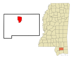
 Location of Wiggins, Mississippi |
|
| Location in the United States | |
| Coordinates: 30°51′31″N 89°8′16″W / 30.85861°N 89.13778°WCoordinates: 30°51′31″N 89°8′16″W / 30.85861°N 89.13778°W | |
| Country | United States |
| State | Mississippi |
| County | Stone |
| Area | |
| • Total | 11.3 sq mi (29.2 km2) |
| • Land | 10.8 sq mi (27.9 km2) |
| • Water | 0.5 sq mi (1.3 km2) |
| Elevation | 262 ft (80 m) |
| Population (2012) | |
| • Total | 4,504 |
| • Density | 420.1/sq mi (170.1/km2) |
| Time zone | Central (CST) (UTC-6) |
| • Summer (DST) | CDT (UTC-5) |
| ZIP code | 39577 |
| Area code(s) | 601 |
| FIPS code | 28-80160 |
| GNIS feature ID | 0679669 |
| Website | http://www.cityofwiggins.com/ |
Wiggins is a city in Stone County, Mississippi, United States. It is part of the Gulfport–Biloxi, Mississippi Metropolitan Statistical Area. The population was 4,390 at the 2010 census. It is the county seat of Stone County.
Wiggins is named after Wiggins Hatten, the father of Madison Hatten, one of the area's original homesteaders. It was incorporated in 1904, and the 1910 census reported 980 residents. In the early 1900s, Wiggins prospered along with the booming timber industry. Wiggins was once headquarters of the Finkbine Lumber Company.
On January 21, 1910, between the hours of 11 am and 1 pm, more than half of the Wiggins business district was destroyed by fire. The fire started from unknown origin in the Hammock Building, a lodging house, and spread rapidly because of strong winds from the northwest. With no city fire department or waterworks, the residents of Wiggins resorted to bucket brigades and dynamite to stop the fire, which was confined to the east side of the Gulf and Ship Island Railroad. The fire consumed 41 business establishments, including the Gulf and Ship Island Railroad depot. Only two or three residential dwellings were destroyed, because most homes were built away from the business district.
Wiggins has long been known for its pickle production, and at one time boasted of being home to the world's largest pickle processing facility. However, the pickle processing facility is now closed, and although the timber industry has declined since the boom years, it still sustains many businesses in Wiggins.
After the 1910 fire and until the 1960s, the center of commerce for Wiggins developed on both sides of Pine Avenue, that sloped downhill and eastward, perpendicular to U.S. Route 49 and Railroad Street (First Street), over a distance of one city block. Small shops were built mainly of brick and were mostly contiguous to each other. Over the years, the shops were occupied by numerous businesses that included drug stores, law offices, a grocery store, a shoe store, a dry cleaners, 5 & dime stores, auto supply store, barber shops, cafes, a movie theater, dry goods outlet, feed & seed outlet, an army surplus store, beauty salons, clothing stores, gift shops, County Library, and U.S. Post Office. In more recent years, the shops have served as real estate offices, CPA & tax preparer outlets, an antique store, newspaper office, ice cream shop, art & frame shop, food outlets, and stationery shop.
...
Wikipedia

