Olympic Mountains
| Olympic Mountains | |
|---|---|

|
|
| Highest point | |
| Peak | Mount Olympus |
| Elevation | 7,962 ft (2,427 m) |
| Coordinates | 47°48′04″N 123°42′39″W / 47.80111°N 123.71083°W |
| Geography | |
| Country | United States |
| State | Washington |
| Range coordinates | 47°50′N 123°50′W / 47.83°N 123.83°WCoordinates: 47°50′N 123°50′W / 47.83°N 123.83°W |
| Parent range | Pacific Coast Ranges |
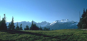
The Olympic Mountains are a mountain range on the Olympic Peninsula of western Washington in the United States. The mountains, part of the Pacific Coast Ranges, are not especially high – Mount Olympus is the highest at 7,962 ft (2,427 m); however, the eastern slopes rise out of Puget Sound and the western slopes are separated from the Pacific Ocean by the 20 to 35 km (12 to 22 mi) wide Pacific Ocean coastal plain. The western slopes are the wettest place in the 48 contiguous states. Most of the mountains are protected within the bounds of the Olympic National Park.
The mountains are spread out across four counties: Clallam, Grays Harbor, Jefferson and Mason. Physiographically, they are a section of the larger Pacific Border province, which is in turn a part of the larger Pacific Mountain System.
The Olympics have the form of a cluster of steep-sided peaks surrounded by heavily forested foothills and incised by deep valleys. They are surrounded by water on three sides, separated from the Pacific by the 20 to 35 km (12 to 22 mi) wide coastal plain. The general form of the range is more or less circular, or somewhat horseshoe-shaped, and the drainage pattern is radial.
Rivers radiate outwards to all sides. Clockwise from windward to leeward, the major watersheds are: Wynoochee, Humptulips, Quinault, Queets, Hoh, Bogachiel (all flowing into the Pacific; the Wynoochee by way of the Chehalis River, and the Humptulips by way of Grays Harbor), Lyre, Elwha, Dungeness (all flowing into the Strait of Juan de Fuca), Big Quilcene, Dosewallips, Duckabush, Hamma Hamma, and Skokomish (all flowing into Hood Canal).
...
Wikipedia
