North Shore City
| North Shore | |
|---|---|
| Suburban area | |

A southern part of North Shore viewed from Forrest Hill, with central Auckland in the background
|
|
 North Shore within the North Island of New Zealand |
|
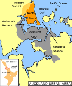
 North Shore (in orange) within the Auckland metropolitan area |
|
| Country |
|
| Island | North Island |
| Region | Auckland |
| Area | |
| • Total | 129.81 km2 (50.12 sq mi) |
| Population (2006 census) | |
| • Total | 205,605 |
| • Density | 1,600/km2 (4,100/sq mi) |
| Time zone | NZST (UTC+12) |
| • Summer (DST) | NZDT (UTC+13) |
North Shore is the part of the urban area of Auckland, New Zealand, located to the north of the Waitemata Harbour.
North Shore was formerly North Shore City, a distinct territorial authority district, which was governed by the North Shore City Council from 1989 until 2010, when it was incorporated into Auckland Council. The city had an estimated population of 229,000 at 30 June 2010, making it the fourth most populous city in New Zealand prior to the November 2010 reorganisation. The former city was also the country's fourth largest city in land, with an area of 129.81 square kilometres and a coastline of 141 kilometres. It was also the most densely populated city in the country because, unlike other New Zealand cities, most of the city's area was urban or suburban in character.
The North Shore comprises a large suburban area to the north of downtown Auckland; linked to the rest of the greater Auckland metropolitan area by two harbour bridges – the Auckland Harbour Bridge crosses the inner Waitemata Harbour to Auckland City, while the Upper Harbour Bridge provides a connection to Auckland's western suburbs Waitakere across the northern stretches of the harbour.
The North Shore has been administered by various councils over the years, in the most recent past the North Shore City Council. On 1 November 2010, North Shore City Council and the six other local councils and Auckland Regional Council merged to create Auckland Council.
The administrative area of North Shore City Council was bounded by Rodney District to the north, Waitemata Harbour to the south and the Rangitoto Channel of the Hauraki Gulf to the east. The seat of the council was in Takapuna. The city was divided into three wards, Harbour, Northern and Central, and each ward is further divided into two community boards. Inner suburbs include Milford, Takapuna, Belmont, Devonport, Bayswater, Northcote, Birkenhead, Highbury, Hillcrest, Glenfield, Wairau Valley, Westlake and Forrest Hill. Outer suburbs include Birkdale, Beach Haven, North Harbour, Albany, Greenhithe, Long Bay*, Torbay*, Waiake*, Browns Bay*, Rothesay Bay*, Murrays Bay*, Mairangi Bay*, Campbells Bay*, Sunnynook and Castor Bay. Those here with an asterisk, along with several other beaches on the Hauraki Gulf coast, are collectively known as East Coast Bays.
...
Wikipedia
