Magnificent Mile
| Magnificent Mile | |
|---|---|
| Neighborhood and street | |
| Magnificent Mile | |

Chicago's Magnificent Mile looking South
|
|
| Nickname(s): The Mag Mile | |
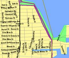
 Streetmap |
|
| Coordinates: 41°53′43″N 87°37′28″W / 41.89535°N 87.62432°WCoordinates: 41°53′43″N 87°37′28″W / 41.89535°N 87.62432°W | |
| Country | United States |
| State | Illinois |
| County | Cook |
| City | Chicago |
| Community areas |
List
|
| Time zone | CST (UTC-6) |
| • Summer (DST) | CDT (UTC-5) |
The Magnificent Mile, sometimes referred to as The Mag Mile, is an upscale section of Chicago's Michigan Avenue, running from the Chicago River to Oak Street in the Near North Side. The district is located adjacent to downtown, and one block east of Rush Street. The Magnificent Mile serves as the main thoroughfare between Chicago's Loop business district and its Gold Coast. It is generally the western boundary of the Streeterville neighborhood, to its east and River North to the west.
Real estate developer Arthur Rubloff of Rubloff Company gave the district its nickname in the 1940s. Currently Chicago's largest shopping district, various mid-range and high-end shops line this section of the street; approximately 3,100,000 square feet (290,000 m2) are occupied by retail, restaurants, museums and hotels. To date, rent on The Magnificent Mile is the eighth most expensive in the country, behind Fifth Avenue in New York and Rodeo Drive in Beverly Hills.
Several of the tallest buildings in the United States, such as the John Hancock Center and the Trump International Hotel and Tower, lie in the district. Landmarks along the Magnificent Mile include Wrigley Building, Tribune Tower, the Chicago Water Tower, and the Allerton Hotel.
...
Wikipedia
