Interstate 4
| Interstate 4 | |||||||
|---|---|---|---|---|---|---|---|
 |
|||||||
| Route information | |||||||
| Maintained by FDOT | |||||||
| Length: | 132.298 mi (212.913 km) | ||||||
| Existed: | 1957 – present | ||||||
| Major junctions | |||||||
| West end: |
|
||||||
| East end: |
|
||||||
| Location | |||||||
| Counties: | Hillsborough, Polk, Osceola, Orange, Seminole, Volusia | ||||||
| Highway system | |||||||
|
|||||||
| State Road 400 | |
|---|---|
| Location: | Tampa-Daytona Beach |
| Length: | 136.514 mi (219.698 km) |
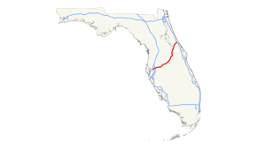
Interstate 4 (I-4) is a 132.298-mile-long (212.913 km) Interstate Highway in the U.S. state of Florida, along a southwest–northeast axis from I-275 in Tampa to I-95 at Daytona Beach. The entirety of I-4 overlaps nearly the entirety of State Road 400 (SR 400), which extends as a contiguous, signed 4.216-mile (6.785 km) surface street in Daytona Beach from I-95 to US Highway 1 (US 1, also SR 5). I-4 has no auxiliary Interstate Highway spurs or loops; however, it intersects several tolled expressways—designated as state roads—that serve as spur and partial loop routes in the Orlando metropolitan area, which (unlike most major U.S. cities) lacks any auxiliary interstate highways.
The first segment of I-4 opened to traffic in 1959 and the highway was largely completed in 1967. I-4's original western terminus was in St. Petersburg, but in 1971 the highway segment from St. Petersburg to its present terminus at I-275 was redesignated as part of I-75 before being redesignated again as I-275. The median of I-4 between Tampa and Orlando was the planned route of a high-speed rail line between these cities, which was cancelled in 2011. The "I-4 corridor" is a strategic region in politics, due to the large number of undecided voters in a large swing state.
...
Wikipedia

