Flowood, Mississippi
| Flowood, Mississippi | |
|---|---|
| City | |
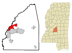
 Location of Flowood, Mississippi |
|
| Location in the United States | |
| Coordinates: 32°19′0″N 90°6′53″W / 32.31667°N 90.11472°WCoordinates: 32°19′0″N 90°6′53″W / 32.31667°N 90.11472°W | |
| Country | United States |
| State | Mississippi |
| County | Rankin |
| Government | |
| • Mayor | Gary Rhoads |
| Area | |
| • Total | 16.6 sq mi (42.9 km2) |
| • Land | 16.3 sq mi (42.2 km2) |
| • Water | 0.3 sq mi (0.7 km2) |
| Elevation | 269 ft (82 m) |
| Population (2010) | |
| • Total | 7,823 |
| • Density | 472.3/sq mi (182.35/km2) |
| Time zone | Central (CST) (UTC-6) |
| • Summer (DST) | CDT (UTC-5) |
| ZIP code | 39232 |
| Area code(s) | 601 |
| FIPS code | 28-25100 |
| GNIS feature ID | 0670061 |
| Website | www |
Flowood is a city in Rankin County, Mississippi. The population was 7,823 at the 2010 census. It is part of the Jackson Metropolitan Statistical Area.
Flowood is located at 32°19′0″N 90°6′53″W / 32.31667°N 90.11472°W (32.316673, -90.114858).
According to the United States Census Bureau, the city has a total area of 16.6 square miles (43 km2), of which 16.3 square miles (42 km2) is land and 0.3 square miles (0.78 km2) (1.69%) is water. The city limits of Flowood include 10 miles of the Lakeland Dr (Hwy 25) corridor from the Pearl River at the Jackson city limits to Hwy 471 north of Brandon.
In June 2009 Flowood voters approved (by a 75%-25% margin) being classified as a resort area which allows liquor by the glass in restaurants and hotels, coming out from under a dry county.
Flowood is also the location of the National Weather Service office that serves the Jackson area.
The Flowood R/C Park is the very first of its kind. It is the only city-owned indoor R/C park in the country. Please visit Flowoodrc.com for more info.
As of the census of 2000, there were 4,750 people, 2,130 households, and 1,145 families residing in the city. The population density was 291.7 people per square mile (112.7/km²). There were 2,371 housing units at an average density of 145.6 per square mile (56.2/km²). The racial makeup of the city was 79.92% White, 16.63% African American, 0.17% Native American, 1.89% Asian, 0.06% Pacific Islander, 0.61% from other races, and 0.72% from two or more races. Hispanic or Latino of any race were 1.77% of the population.
...
Wikipedia

