Drina
| Drina | |
|---|---|

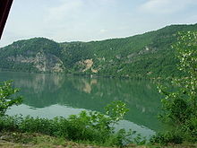
The Drina River near Mali Zvornik, Serbia
|
|
| Country | Bosnia and Herzegovina, Serbia, Croatia |
| Basin features | |
| Main source | Bosnia and Herzegovina, between the slopes of the Maglić and Pivska planina mountains |
| River mouth | Sava, at the Serbian-Bosnian border between Crna Bara and Bosanska Rača |
| Basin size | 19,570 km2 (7,560 sq mi) |
| Physical characteristics | |
| Length | 346 km (215 mi) |
| Discharge |
|
The Drina (Serbian Cyrillic: Дрина, pronounced [drǐːna]) is a 346 km (215 mi) long international river, which forms a large portion of the border between Bosnia and Herzegovina and Serbia. It is the longest tributary of the Sava River and the longest karst river in the Dinaric Alps which belongs to the Danube river watershed. Its name is derived from the Latin name of the river (Latin: Drinus) which in turn is derived from Greek (Ancient Greek: Dreinos).
The Drina is formed by the confluence of the Tara and the Piva rivers, both of which flow from Montenegro and converge on the border of Bosnia and Herzegovina, at Hum and Šćepan Polje villages. The total length of the Tara river is 144 km (89 mi), of which 104 km (65 mi) are in Montenegro, while the final 40 km (25 mi) are in Bosnia and Herzegovina along which form the border between the two countries in several places. The Drina flows through Bosnia and Herzegovina northward for 346 km (215 mi), of which 206 km (128 mi) is along the border of Bosnia and Herzegovina and Serbia, and finally spills out into the Sava river near Bosanska Rača village in northeastern Bosnia and Herzegovina. Measured from the source of the Tara, its longer headwater, the Drina is 487 kilometers (303 miles) long.
...
Wikipedia
