Coralville, Iowa
| Coralville, Iowa | ||
|---|---|---|
| City | ||

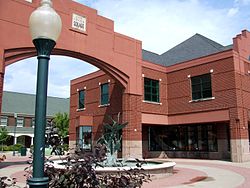
City Center Square in downtown Coralville
|
||
|
||
 Location of Coralville, Iowa |
||
| Coordinates: 41°41′18″N 91°35′12″W / 41.68833°N 91.58667°WCoordinates: 41°41′18″N 91°35′12″W / 41.68833°N 91.58667°W | ||
| Country |
|
|
| State |
|
|
| County | Johnson | |
| Metro | Iowa City Metropolitan Area | |
| Incorporated | 1873 | |
| Government | ||
| • Type | Council-manager government | |
| • Mayor | John Lundell | |
| • City Administrator | Kelly Hayworth | |
| Area | ||
| • Total | 12.05 sq mi (31.21 km2) | |
| • Land | 12.01 sq mi (31.11 km2) | |
| • Water | 0.04 sq mi (0.10 km2) | |
| Elevation | 682 ft (208 m) | |
| Population (2010) | ||
| • Total | 18,907 | |
| • Estimate (2013) | 20,092 | |
| • Rank | 23rd in Iowa | |
| • Density | 1,574.3/sq mi (607.8/km2) | |
| Time zone | Central (CST) (UTC-6) | |
| • Summer (DST) | CDT (UTC-5) | |
| ZIP code | 52241 | |
| Area code(s) | 319 | |
| FIPS code | 19-16230 | |
| GNIS feature ID | 0455624 | |
| Website | www.coralville.org | |
Coralville is a city in Johnson County, Iowa, United States. It is a suburb of Iowa City and part of the Iowa City Metropolitan Statistical Area. The population was 18,907 at the 2010 census.
Coralville is the location of the Edgewater Park Site, a 3,800-year-old archaeological site along the Iowa River. Edgewater is the oldest site in Iowa with evidence of domesticated plant use.
Coralville incorporated as a city in June first, 1857. The city's name comes from the fossils that are found in the limestone along the Iowa River. In 1864 Louis Agassiz, a Harvard University zoologist, gave a lecture at the nearby University of Iowa titled “The Coral Reefs of Iowa City”. During the lecture he presented local samples of fossilized Devonian period coral.[1] The lecture was well received and helped raise public interest in the local fossils. In 1866, more corals were discovered at the site of a new mill, inspiring the citizens of the area to name the settlement "Coralville". The first mill at Coralville was built in 1844, and in the years that followed, a number of mills were powered by the Coralville mill dam along the Iowa River,[2] but all of the mills had closed by 1900, except for a low-head hydroelectric plant that remained in operation until the mid 20th century.
Coralville is also the location where some 1300 Mormon immigrants stopped to make camp in their migration of 1856 after having traveled west by rail to Iowa City, which was the westernmost rail terminus at the time. They built handcarts out of native woods during their encampment so that an adult could haul a 600–700 pound load and cover about 15 miles per day on foot in their continuing trek to Salt Lake City. A historical marker commemorating the Mormon Handcart Brigade was erected in 1936 by the Iowa Society DAR, with members of the Pilgrim Chapter present. Originally placed just south of 5th Street and west of 10th Street, it was moved in 1998 to S. T. Morrison Park and rededicated by the Nathaniel Fellows Chapter, placed near the entrance and pond. Today, the Mormon Handcart Park and Nature Preserve commemorates the site. There is also a street, Mormon Trek Blvd, named for the Mormons who went through that area.
...
Wikipedia

