
Cloppenburg
| Cloppenburg | ||
|---|---|---|
 |
||
|
||

Cloppenburg
|
||
|
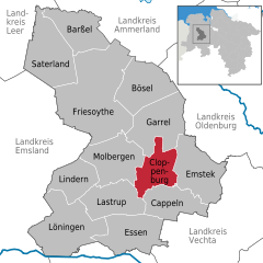
Location of Cloppenburg within Cloppenburg district
  |
||
| Coordinates: 52°51′N 8°3′E / 52.850°N 8.050°ECoordinates: 52°51′N 8°3′E / 52.850°N 8.050°E | ||
| Country | Germany | |
| State | Lower Saxony | |
| District | Cloppenburg | |
| Government | ||
| • Mayor | Wolfgang Wiese (CDU) | |
| Area | ||
| • Total | 70.62 km2 (27.27 sq mi) | |
| Elevation | 39 m (128 ft) | |
| Population (2015-12-31) | ||
| • Total | 33,798 | |
| • Density | 480/km2 (1,200/sq mi) | |
| Time zone | CET/CEST (UTC+1/+2) | |
| Postal codes | 49661 | |
| Dialling codes | 04471 | |
| Vehicle registration | CLP | |
| Website | www.cloppenburg.de | |

Cloppenburg is a town in Lower Saxony, Germany, capital of Cloppenburg District and part of Oldenburg Münsterland. It lies 38 km south-south-west of Oldenburg in the Weser-Ems region between Bremen and the Dutch border. Cloppenburg is not far from the A1, the major motorway connecting the Ruhr area to Bremen and Hamburg. Another major road is the federal highway B213 being the shortest link from the Netherlands to the A1 and thus to Bremen and Hamburg.
The town is a centre for the largely agricultural region of southern Oldenburg. It is the administrative centre of the district and there are many schools.
However, there is also some industry in town: e.g. Lumberg, (connector systems) and Derby Cycle (bikes).
The town had strong cultural links with St Munchins Parish in Limerick, Ireland from the 1970s to the 1990s. During this period many groups of teens/young adults from both areas visited and were hosted by families from the other area. It was a very successful exchange program fostering some lifelong friendships.
One of Cloppenburg's main tourist attractions is the Museumsdorf Cloppenburg, a collection of old buildings from the region that were dismantled and reassembled in the museum.
...
Wikipedia