Azores
| Azores (Açores) | |||
| Autonomous Region (Região Autónoma) | |||
|
Mount Pico and the green landscape, emblematic of the archipelago of the Azores
|
|||
|
|
|||
| Official name: Região Autónoma dos Açores | |||
| Name origin: açor, Portuguese for species of raptor, erroneously identified as goshawks; also derivation from the word for blue | |||
|
Motto: Antes morrer livres que em paz sujeitos (English: "Rather die as free men than be enslaved in peace") |
|||
| Country | |||
|---|---|---|---|
| Autonomous Region | |||
| Region | Atlantic Ocean | ||
| Subregion | Mid-Atlantic Ridge | ||
| Position | Azores Platform | ||
| Islands | Corvo, Faial, Flores, Graciosa, Pico, São Jorge, São Miguel, Santa Maria, Terceira | ||
| Municipalities | Angra do Heroísmo, Horta, Lagoa, Lajes das Flores, Lajes do Pico, Madalena, Nordeste, Povoação, Praia da Vitória, Ponta Delgada, Ribeira Grande, Santa Cruz da Graciosa, Santa Cruz das Flores, São Roque, Vila do Corvo, Vila do Porto, Vila Franca do Campo | ||
| Capital | Ponta Delgada | ||
| Largest city | Ponta Delgada | ||
| - center | São José | ||
| - elevation | 22 m (72 ft) | ||
| - coordinates | 37°44′28″N 25°40′32″W / 37.74111°N 25.67556°WCoordinates: 37°44′28″N 25°40′32″W / 37.74111°N 25.67556°W | ||
| Highest point | Mount Pico | ||
| - elevation | 2,351 m (7,713 ft) | ||
| - coordinates | 38°28′19″N 28°51′50″W / 38.47194°N 28.86389°W | ||
| Lowest point | Sea level | ||
| - location | Atlantic Ocean | ||
| - elevation | 0 m (0 ft) | ||
| Area | 2,333 km2 (901 sq mi) | ||
| Population | 245,746 (2012) Census 2011 | ||
| Density | 105.87/km2 (274/sq mi) | ||
| Settlement | 15 August 1432 | ||
| - Administrative autonomy | c. 1895 | ||
| - Political autonomy | 4 September 1976 | ||
| Discovery | c. 1427 | ||
| - Santa Maria | c. 1427 | ||
| - São Miguel | c. 1428 | ||
| Management | |||
| - location | Assembleia Regional, Rua Marcelino Lima, Horta, Faial | ||
| - elevation | 46 m (151 ft) | ||
| - coordinates | 38°32′6″N 28°37′51″W / 38.53500°N 28.63083°W | ||
| Government | |||
| - location | Palácio de Santana, Rua José Jácome Correia, Ponta Delgada, São Miguel | ||
| - elevation | 60 m (197 ft) | ||
| - coordinates | 37°44′52″N 25°40′19″W / 37.74778°N 25.67194°W | ||
| President (Government) | Vasco Cordeiro (PS) | ||
| - President (Assembleia) | Ana Luís (PS) | ||
| Timezone | AZOT (UTC−1) | ||
| - summer (DST) | AZOST (UTC) | ||
| ISO 3166-2 code | PT-20 | ||
| Postal code | 9XXX-XXX | ||
| Area code | (+351) 29X XX XX XX | ||
| ccTLD | .pt | ||
| Date format | dd-mm-yyyy | ||
| Drive | right-side | ||
| Demonym | Azorean | ||
| Patron Saint | Espírito Santo | ||
| Holiday | 51st day (Monday) following Easter (Dia da Região Autónoma dos Açores) | ||
| Anthem |
A Portuguesa (national) Hino dos Açores (regional) |
||
| Currency | Euro (€) | ||
| GDP (nominal) | 2013 | ||
| - Total | € 3,694 million | ||
| - Per capita | € 14,900 | ||
|
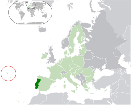
Location of the Azores relative to Portugal (green) and the rest of the European Union (dark blue)
|
|||
| Statistics: Instituto Nacional de Estatística | |||
| Website: www.azores.gov.pt | |||
| Geographic detail from CAOP (2010) produced by Instituto Geográfico Português (IGP) | |||
The Azores (/əˈzɔərz/ ə-ZOHRZ or /ˈeɪzɔərz/ AY-zohrz; Portuguese: Açores, [ɐˈsoɾɨʃ]), officially the Autonomous Region of the Azores (Região Autónoma dos Açores), is one of the two autonomous regions of Portugal, an archipelago composed of nine volcanic islands in the North Atlantic Ocean about 1,360 km (850 mi) west of continental Portugal, about 880 km (550 mi) northwest of Madeira, and about 1,925 km (1,196 mi) southeast of Newfoundland.
Its main industries are agriculture, dairy farming (for cheese and butter products primarily), livestock ranching, fishing, and tourism, which is becoming the major service activity in the region. In addition, the government of the Azores employs a large percentage of the population directly or indirectly in the service and tertiary sectors. The main settlement of the Azores is Ponta Delgada.
...
Wikipedia


