Štip
|
Štip Штип |
|||
|---|---|---|---|
| Shtip | |||

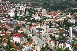
View of Štip
|
|||
|
|||
| Location within Macedonia | |||
| Coordinates: 41°44′15.01″N 22°11′36.81″E / 41.7375028°N 22.1935583°ECoordinates: 41°44′15.01″N 22°11′36.81″E / 41.7375028°N 22.1935583°E | |||
| Country |
|
||
| Municipality | Štip Municipality | ||
| Founded | 1st century AD | ||
| Government | |||
| • Mayor | Ilcho Zahariev (VMRO-DPMNE) | ||
| Population () | |||
| • Total | 47,796 | ||
| Time zone | CET (UTC+1) | ||
| • Summer (DST) | CEST (UTC+2) | ||
| Postal code | 2000 | ||
| Area code(s) | +389 32 | ||
| Car plates | ŠT | ||
| Climate | Cfa | ||
| Website | www.Stip.gov.mk/ | ||
Štip (Macedonian: Штип [ʃtip]) is the largest urban agglomeration in the eastern part of the Republic of Macedonia, serving as the economic, industrial, entertainment and educational focal point for the surrounding municipalities. As of the 2002 census, the Štip municipality alone had a population of about 47,796. Štip is the largest textile production center in the country; Center of the fashion industry in Macedonia, as well as the location of the sole public university in eastern Macedonia, Goce Delčev University of Štip. The city of Štip is the seat of Štip Municipality.
The city is located at the intersection of the Lakavica, Ovče Pole, and Kočani valleys. Two rivers pass through Štip, the Bregalnica which is the second largest in the Republic of Macedonia, and the Otinja which divides the city center. The hill Isar, with its early medieval fortress on top, dominates the city and provides for the common reference as "The city under the Isar'. The area surrounding the city is suffering from deforestation which is contributing to the temperature extremes, summers being hot and dry with mean temperatures around 32 °C (90 °F) and days above 40 °C (104 °F) being common. Winters are short (less than 2 months usually) and mild (though considered cold for the area) with normals around −2 °C (28 °F), but with occasional drops down to −10 °C (14 °F). Spring usually comes in February, when most of the foliage is regenerating, although freak snow storms could appear as late as May.
The soil is mostly sandy, and has large patches of red soil (Macedonian: Црвеница, crvenica) which indicates large percentage of Iron in the soil. The geographical area of the city of Štip is bordered by the mountain Plačkovica east, by the Krivolak valley south-east, the estuary of the river Bregalnica in the south-west, and by its alluvial plain in the north.
...
Wikipedia


