Óbidos, Portugal
| Óbidos | |||
|---|---|---|---|
| Municipality | |||

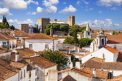
A view of Óbidos
|
|||
|
|||
 |
|||
| Coordinates: 39°21′29″N 9°9′28″W / 39.35806°N 9.15778°WCoordinates: 39°21′29″N 9°9′28″W / 39.35806°N 9.15778°W | |||
| Country |
|
||
| Region | Centro | ||
| Subregion | Oeste | ||
| Intermunic. comm. | Oeste | ||
| District | Leiria | ||
| Parishes | 7 | ||
| Government | |||
| • President | Telmo Henrique Correia Daniel Faria (PPD-PSD) | ||
| Area | |||
| • Total | 141.55 km2 (54.65 sq mi) | ||
| Elevation | 49 m (161 ft) | ||
| Highest elevation | 221 m (725 ft) | ||
| Lowest elevation | 0 m (0 ft) | ||
| Population (2011) | |||
| • Total | 11,772 | ||
| • Density | 83/km2 (220/sq mi) | ||
| Time zone | WET/WEST (UTC+0/+1) | ||
| Postal code | 2510 | ||
| Area code | 295 | ||
| Patron | Santa Maria | ||
| Website | www |
||
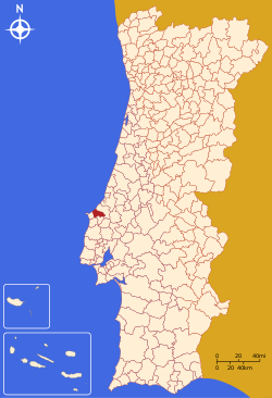
Óbidos (Portuguese pronunciation: [ˈɔβiðuʃ]) is a town (Portuguese: vila) and a municipality in the Oeste Subregion in Portugal. The town proper has approximately 3100 inhabitants. The municipality population in 2011 was 11,772, in an area of 141.55 square kilometres (54.65 square miles).
The name "Óbidos" probably derives from the Latin term oppidum, meaning "citadel", or "fortified city". The municipality had its origin in an early Roman settlement near the foothills of an elevated escarpment. The region of Óbidos, extending from the Atlantic to the interior of Estremadura Province along the rivers and lakes has been inhabited since the late Paleolithic. A settlement was constructed by early Celt tribes, that was later a centre of trade for the Phoenicians. Archeological evidence from the base of the medieval tower (south of Facho) at Óbidos Castle indicates Roman construction linked to an outpost of the Roman civitas of Eburobrittium, a large urban area that has been under excavation. Archeological surveys determined the remains of a forum, baths and other Roman structures near the settlement.
After the fall of Rome, the region came under the influence of the Visigoths, although specific records are missing. The Roman town of Eburobrittium was abandoned in the 5th century for the more secure hilltop where today the principal settlement is located. Sometime after 713 the Moors established a fortification on this mountain, while a Christian community of Mozarabs lived in the Moncharro neighbourhood.
...
Wikipedia


